
Elephant Mountain Gold Project, Alaska
Overview
The Elephant Mountain Project (the "Project") consists of three properties (Elephant, Trout and Wolverine) located in the Rampart-Eureka-Manley Hot Springs placer gold mining districts near Eureka, Alaska. The Project can be accessed by the Elliott all-weather highway and then seasonal road from Eureka, a placer mining area located about 76 miles (123 kilometres ("km")) northwest of Fairbanks.
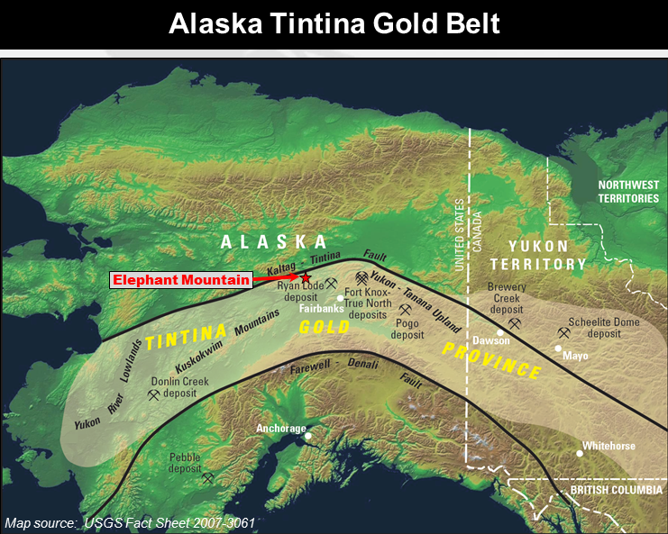
The Elephant Mountain Project area is interpreted to be part of the family of reduced intrusion-related gold system (RIRG) similar to Kinross Gold Corp.'s Fort Knox Mine, Ryan Lode and True North deposits located in the nearby Fairbanks Gold Mining district in Alaska, other deposits like Golden Summit and Vinasale in Alaska, as well as the Brewery Creek, Dublin Gulch (Eagle) and Coffee deposits in the Yukon. All of these RIRG deposits are interpreted to be related to late Cretaceous-aged intrusive events within the Tintina Gold Province of Alaska and the Yukon, and, are associated with historic placer gold mining activity. The area of the Project, is in part, drained by Eureka, Pioneer and Quail Creeks. Alluvial gold was first discovered in Eureka Creek in 1898 and Eureka, Pioneer and Quail Creeks are three of the most significant alluvial gold bearing creeks in this historic gold district.
Within these two properties, which collectively encompass 10,240 acres, six (6) km-scale gold targets have been sufficiently advanced to warrant drilling. All are associated with a Cretaceous-aged intrusive complex and related alteration system that extends for at least twelve (12) km from the southwest to the northeast. Two of the gold targets have been drill-tested by the Company resulting in highlights of 4.09 grams per tonne ("gpt") gold over 4.6 metres ("m") in the South Zone and 0.40 gpt gold over 147.1 m in the North Zone, with these intersections in drill holes separated by 1.4 km. . Three other targets on the Trout-Wolverine Property about 10 km to the NE have each returned grab samples over 10 gpt gold with highest values up to 23.0 gpt gold. Two of these targets are also associated with wide low-grade gold in hand excavated trenches.
| Target Name | Claim Group |
Soil (Max. ppb Gold) | Best Rock Results (gpt Gold) |
Best Drill Results | IP Target Size or Trench Gold |
|---|---|---|---|---|---|
| North Zone | Elephant | 320 | 1.92, 1.88, 1.83 | 0.40 gpt Au / 147.1 m | 1200 m x 600 m |
| South Zone | Elephant | 310 | 411.4 and 12.98 | 4.09 gpt Au / 4.6 m | 200 m x 50 m |
| Central Zone | Elephant | 85 | Elephant Mountain Fault Zone | Ready to drill | Deep 500 m x 150 m |
| Pump Zone | Elephant | 150 | 1.31, 1.14 | Ready to drill | 600 m x 150 m |
| Trout Peak | Trout-Wolverine | 2330 | 23.0 | Ready to drill | 0.51 gpt Au / 12.19 m |
| South Fork | Trout-Wolverine | 83 | 10.35, 6.73, 6.60 | Ready to drill | 0.547 gpt Au / 9.14 m |
| Wolverine | Trout-Wolverine | 90 | 11.65 | Needs work | No IP - no trench |
Elephant Mountain Property
The Elephant Property is adjacent to the Elliott Highway at the southwest extension of the Project area. In 1992, a large intrusive-hosted gold-arsenic soil geochemical anomaly was identified that extends for at least 6,000 feet (1,830 m) and up to 1,500 feet (457 m) wide, with peak values up to 1,540 parts per billion ("ppb") gold. Further work by the Company has defined four (4) high quality drill targets associated with this historic soil anomaly and nearby IP chargeability targets all hosted within or on the margins of a multi-phase Cretaceous-aged granodiorite, diorite, syenomonzonite and granite pluton.
South Zone Discovery Target
On the Elephant Property, the Company is exploring the South Zone Target with the objective of discovering higher grade structures. After acquisition, the Company completed deep auger soil sampling program identifying a gold-arsenic-antimony soil anomaly encompassing a 1,200 m by 250 m area with gold values exceeding 100 ppb gold (up to 320 ppb gold). The highest gold values in rock samples from the Elephant Property come from this target. Prospecting and sampling by the Company has resulted gold values in grab samples of quartz vein material from the intrusive including 12.98 gpt, 5.21 gpt, 4.44 gpt, 3.02 gpt, 2.59 gpt and 2.18 gpt gold. Historically, a stibnite (antimony sulphide) bearing grab sample collected in 1991 assayed 12 ounces per ton gold (411.4 gpt gold).
The Company completed four diamond drill holes from three setups on the South Zone Target with significantly encouraging results reported from the first two drill holes. Weighted average gold results for the mineralized zone in two closely spaced holes are 4.09 gpt gold over 4.6 m and 3.87 gpt gold over 4.6 m. True width is currently unknown.
Summary of South Zone Target Intersections - Drill Holes EL 16-14A & EL 16-14B
(Azimuth 235 degrees, Dip -45 degrees)
| Drill Hole | From (m) | To (m) | Interval (m) | Gold (gpt) | Silver (gpt) |
|---|---|---|---|---|---|
| EL 16-14A | 18.3 | 22.9 | 4.6 | 4.09 | 2.8 |
| Includes | 18.3 | 19.3 | 1.0 | 3.82 | 2.2 |
| Includes | 20.7 | 21.3 | 0.67 | 20.39 | 12.1 |
| EL 16-14B | 15.2 | 19.8 | 4.6 | 3.87 | 2.5 |
| Includes | 15.2 | 16.1 | 0.91 | 3.75 | 2.8 |
| Includes | 17.8 | 18.3 | 0.52 | 24.90 | 11.5 |
The gold mineralization encountered in this drilling is related to a zone of inter-layered diorite and syenomonzonite associated with pervasive pyrite-arsenopyrite, calcite and silica replacement of the diorite layer with a massive stibnite bearing fault fill that appears to parallel to sub-parallel a contact between a diorite layer and the syenomonzonite with the associated high grade intercepts of 20.39 gpt and 24.9 gpt gold correlated at this location in both drill holes. The structure that hosts the massive stibnite is currently interpreted to be a steeply dipping structural zone striking northwest parallel to the eastern margin of the South Zone soil anomaly. Further drilling is warranted to step out on this drill discovery.
At the South Zone, an IP survey completed by the Company defined a resistivity anomaly associated with the encouraging sulphide intersections in the above drill holes. Adjacent and on the east side of this resistivity feature and these discovery drill holes is a near surface chargeability feature with a strike length of between 100 and 200 m. This South Zone chargeability feature remains untested by drilling and is interpreted to represent a preserved sulphide rich zone in the intrusive in this area, not yet explained or tested by drilling.
The remaining two drill holes that tested the South Zone anomaly transected primarily well oxidized variably sheared and faulted diorite, granodiorite, and/or syenomonzonite with inliers of altered clastic sediments. The best assay results include an intersection of 0.52 gpt gold over 3.04 m which includes 1.13 gpt gold over 1.06 m and 0.59 gpt gold over 2.44 m and 0.48 gpt gold over 2.44 m.
In 2020, some additional soil sampling was completed and successfully extended the linear soil anomaly at Elephant by about 400 m southeast into the area of interpreted hornfels alteration.
North Zone Discovery Target
On the North Zone Target, 1.4 km north of the South Zone, pervasive disseminated pyrite-arsenopyrite with intense sericite alteration of granodiorite is exposed over about one (1) square km area associated with a similar sized gold-arsenic soil anomaly (up to 250 ppb gold). Eight holes were drilled in this area in 1992, with the best of the holes containing an average grade of 0.015 ounce per ton gold (0.514 gpt gold) over an interval of 326 feet (99.4 m) and bottomed in mineralization. In the same area, the Company completed one diamond drill hole EL 16-13 (Dip -45 degrees). EL 16-13 was drilled to a total depth of 180.75 m and encountered silicified and phyllic (sericite) altered granodiorite throughout the entire core length. About 150 m of this length, starting at surface, encountered up to 1.5% pervasive disseminated pyrite and arsenopyrite with arsenopyrite and pyrite bearing quartz veinlets. The entire length of the drill hole is in-part oxidized with the oxidation related to fractures and oxidized quartz-sulphide veinlets. Assay results are 0.40 gpt gold over 147.1 m including 0.63 gpt gold over 48.2 m. True width is currently unknown.
Directly associated with the combined surface alteration, soil anomaly and wide low-grade gold bearing drill intersections, an IP survey completed by the Company defined a two-lobed well-defined chargeability feature estimated at 1,200 x 600 m in size associated with the pervasively sericite altered granodiorite and 1 to 3% disseminated sulphides, quartz veinlets and sulphide-quartz veinlets with associated gold. This IP chargeability feature has two separate target lobes defined by east-west oriented areas of higher chargeability, referred to as the North Zone Target and the Pump Zone Target. A portion of the North Zone Target was tested by the Company's drill hole and was partially tested with drill holes in 1992. A large portion of the chargeability feature associated with the North Zone Target remains untested by drilling.
Pump and Central Zone Targets
The Pump Zone Target a possible southwest extension of the North Zone is located in a covered area immediately to the north of a regional scale east-west trending structure ("Elephant Mountain Fault Zone" or "EMFZ") that transects the intrusive. The EMFZ is evidenced by a prominent east-west striking lower resistivity feature that transects the "resistive" EM intrusive. The Pump Zone has an associated chargeability anomaly which is interpreted to be a south west continuation of the North Zone IP chargeability target and soil anomaly (up to 185 ppb gold in the Pump Zone). Best rock grab samples in this target include 1.3 gpt and 1.14 gpt gold. This target has not been tested with drilling.
The Central Zone Target, a recessive weathering area of late eluvial cover and no outcrop, is located between the North and the South Zones entirely within the EM intrusive and is interpreted to be an area of altered and deeply oxidized intrusive associated with the EMFZ. . Within this target area elevated chargeabilities were noted in the IP survey on the largest separation readings primarily on the north side and within the EMFZ between the South Zone and North Zone Targets. This Central Zone target area also has sporadic anomalous gold-in-soil (up to 140 ppb gold). This target expresses itself at depth (i.e. largest separation readings) because it is interpreted to lie beneath an area of deeper oxidation associated with the EMFZ. This target has not yet been tested with drilling.
Trout - Wolverine Property
The Trout-Wolverine Property is located about nine (9) km northeast of the Elephant Property. This property, part of the Elephant Mountain Project, hosts three significant gold targets, two of which warrant drilling.
Trout Peak Target
The Trout Peak Target consists of a soil anomaly, with gold values in excess of 100 ppb gold that outline a 1,000 m by 300 m mineralized trend which 2018 mapping has now confirmed is associated with a 100 m wide NE-SW striking shear zone ("Trout Shear"). The Trout Shear transects a 1.6 km by 1.2 km multi-phase syenite complex ("TPIC"). The best assay results reported include a grab sample collected in 2018 which assayed 23 gpt gold in silicified syenite within the Trout Shear and TPIC and within the higher gold-in-soil contour. At the Trout Peak Target, more detailed soil sampling has defined a 100 m wide (+50 ppb) gold-in-soil anomaly with a strike length of at least 350 m. Within this soil anomaly is a 50 m wide (+100 ppb) gold-in-soil anomaly of at least 200 m. Peak values within the +100 ppb gold contour include 2,330 ppb and 2,100 ppb gold. The gold-in-soil results are also associated with elevated arsenic-in-soil. Due to oxidation and recessive weathering there is no outcrop over a 100 m portion of the Trout Shear in the area of the highest soil values. Within this area three trenches were hand excavated in 2018 with the best value in trenching returning 0.51 gpt gold over 12.19 m. The gold zones associated with silicified, sheared and quartz veined TPIC in all three trenches was unable to determine the full width of the gold mineralization. The larger 1,000 m long Trout Target soil anomaly (+100 ppb gold) also remains open for expansion in size along strike associated with a portable XRF supported arsenic-in-soil anomaly that exceeds 1,200 by 300 m in size.
In 2020, Some additional soil and rock sampling was completed to further define the location of and edges of the Trout Peak target. Another rock sample collected in 2020 assayed 9.11 gpt gold.
South Fork Target
The South Fork Target is located about two km north of the Trout Peak Target and is hosted within hornfels altered sediments. 2018 mapping has confirmed that the NE-SW trending Trout Shear can be traced from the Trout Peak Target and transects the area of the South Fork Target. Rock sampling has returned values including 10.35 ppm, 6.73 ppm, 6.60 ppm, 5.15 ppm, 4.10 ppm and 3.53 ppm gold, confirming gold potential associated with one or more structural linear features. The four highest gold-in-rock samples also returned 0.48% lead, 1.280% lead, 1.94% lead and 1.205% lead respectively. Mineralization is related to oxidized sulphides associated with quartz veining, vein stockwork, and quartz healed breccia hosted in hornfels altered clastic sediments. Hand excavated trenching has exposed the quartz-breccia over about 9 m in estimated true width associated with quartz breccia and quartz vein stockwork with slickensides and oxidized sulphides. Chip sampling averaged 0.547 ppm gold over 9.14 m including 0.846 ppm gold over 4.57 m. The quartz-breccia mineralization has now been confirmed in grab samples outside of the South Fork trench area (up to 6.73 ppm gold) suggesting that there are other gold-bearing structures at South Fork that have not yet been identified.
North Wolverine Target
The third highly prospective target on the Trout-Wolverine property includes visible gold bearing quartz veinlets in two locations hosted within the north margins of the Wolverine intrusive with assays from grab samples up to 11.65 ppm gold. Orientation talus fine soil sampling has returned values up to 54 ppb gold. Additional systematic field work is required on this target prior to advancing to drill stage.
Option Agreements
In December 2020, Endurance completed the final outstanding payment and vested its 100% ownership interest in the Elephant Property (5,440 acres). The Elephant Property is subject to a 2% net smelter royalty ("Elephant NSR") and Endurance can purchase half of the Elephant NSR at any time for US$750,000.
Under the terms of a continuing option agreement with the private vendor, the Company has an option to earn a 100% ownership in the Trout-Wolverine Property (4,800 acres). Under the terms of the amended 2018 Option Agreement, Endurance can earn a 100% interest in the Trout-Wolverine Property by completing a total of US$200,000 in exploration expenditures (complete), delivering 300,000 Endurance common shares by December 31, 2022 (complete), and making US$180,000 ($150,000 paid) in cash payments by December 31, 2025. The option is subject to a 2% NSR ("Trout-Wolverine NSR") and Endurance can purchase half the Trout-Wolverine NSR at any time for US$500,000.
Recommended Exploration
An independent technical report and recommendations on the Elephant Mountain Project (both claim groups), supported further exploration including drilling of the six targets. Subsequent to completion of this report a program of portable XRF supported geological mapping, rock sampling, soil sampling and trenching was completed and summarised in an additional report on the Trout-Wolverine claim group.
Recommendations for further work from both reports include:
- Diamond Drill testing and/or reverse circulation drilling of the six targets as follows:
- South Zone - complete step-out drilling to build tonnage at the higher grade gold bearing structure intersected in DDH EL16-14 and also explain the strong near-surface IP chargeability anomaly adjoining this discovery at the South Zone Target;
- Evaluate the North Zone Target with multiple drill holes to discover higher grade "feeder" structures possibly evidenced by a more intense east-west IP chargeability trend within the large low-grade gold zone;
- Test the Pump Zone IP chargeability anomaly to explain this anomaly and discover higher grade structures that are evidenced by a more intense east-west IP chargeability trend;
- Test the Central Zone Target to evaluate potential for more intensely oxidized zones of gold mineralization similar to the North Zone or higher grade structures similar to the South Zone;
- Test the Trout Peak Target to define the extent of the intrusive hosted gold at this target and;
- Test the high-grade gold in quartz-breccia zone at the South Fork Target.
- Geophysical grid on the Trout Peak Target (IP and magnetics).
- Expand the soil grid at the South Zone Discovery target.
- Expand the soil grid at the Pump Zone Discovery target.
- Expand the soil grid at the Trout Peak and South Fork Targets -- employ pXRF supported reconnaissance mapping and soil sampling to define the outline of the soil surveys.
- Further reconnaissance scale pXRF supported geological and alteration mapping, soil and rock sampling and grid-based soil sampling on at least six (6) additional targets that have not yet been advanced sufficiently to warrant drilling. Each of these targets have anomalous gold results requiring follow-up.
Robert T. Boyd, P.Geo. is a qualified person as defined in National Instrument 43-101 and supervised the compilation of the information forming the basis for this summary. The exploration activity during the period between 1989 and 1992 preceded the implementation of NI 43-101. Bedrock grab samples are selective by nature and are unlikely to represent average grades within the bedrock when drilled.
All 2012 through 2024 rock and soil samples were analyzed at ALS Minerals using Au-ST43, Au-OG43, and ME-MS41. All split core samples were analyzed at ALS Minerals using Au-AA23, Au-GRA21 (>10 g/t), and ME-MS61L. No assays for antimony or arsenic were completed on core samples with values exceeding 10,000 ppm.