
Bandito REE-Niobium Project, Yukon
Overview
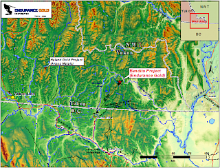
The Company owns 100% interest in the Bandito property which is 3,700 hectares in size and located in the Yukon, 155 kilometres "km" east of Watson Lake, 60 km northeast of the airstrip, and road head at Smith Falls, British Columbia. A cat trail that accessed historic petroleum drilling activity passes within 30 km of the property. The Liard Basin, an emerging shale gas basin is located south east of the property.
The Company has a current Class 1 exploration permit and is considering an application for a more advanced Class 3 exploration permit. Geophysical surveys and field work is being considered for the 2022 field season.
The Bandito property is underlain by Proterozoic-aged argillite, quartzite and stratabound andesite-jasper polymictic breccia which have been intruded by Late Proterozoic-aged (650 Ma) multi-phased reddish coloured nepheline syenite (Red Syenite) with pegmatitic, fine grained and coarse grained phases. The north trending Beaver River Thrust truncates the Proterozoic assemblage on the west edge of the property, with younger Paleozoic sediments on the north, east and west sides of the property. An approximate nine-square km area of the Syenite and host rocks has been altered through potassium and sodium metasomatism and the introduction of hematite and sometimes magnetite.
Alteration occurs both within the Red Syenite, which is fluorite enriched, iron oxide and sericite altered, and in the adjoining Middle Proterozoic-aged sediments in which the host rocks have been hornfels and variably altered to potassium feldspar, albite, carbonates, arfvedsonite, riebeckite, aegirine, magnetite, specular hematite, chlorite, rhodonite, sphene, zircon, monazite, apatite, xenotime, pyrochlore, fluorite, and apatite (Fenite).
Exploration History 1975 to 2014
The Bandito property was explored from the mid 1970's through 1987 for thorium-uranium and rare earth elements (REE), with some encouraging results for REE in multiple samples over the nine square kilometre altered area associated with the Fenite and Red Syenite. Exploration and evaluation work was completed by the following companies:
- 1970's - Eldorado Nuclear -- airborne radiometric survey
- 1977 - Silver Standard Mines -- prospecting for thorium and uranium
- 1980 - E&B Explorations Ltd. option -- thorium-uranium-rare earth exploration
- 1980 to 1987 - Silver Standard Mines Ltd -- rare earth exploration
- 1987 - Unocal Canada and Molycorp -- rare earth acquisition evaluation
- 2004 to 2006 - True North Gems Inc -- nickel exploration, gemstone reconnaissance
- 2010 to 2014 - Endurance Gold Corporation -- niobium, rare earth exploration in syenite/fenite.
Endurance's Rare Earth and Niobium-Tantalum Exploration Results
The results of the rock sampling for the 2011 and 2012 field programs are summarized in a release dated October 12, 2011 and November 5, 2012. Trench and rock sample results for niobium and rare earth are illustrated and summarized on the 2011 REE-Nb summary map and the 2011 and 2012 soil sample compilation maps. A compilation summary report for the property was completed in 2013 and petrographic studies were completed in 2014.
Rare Earth Highlights -- The most significant prospects sampled in 2012 were related to follow-up prospecting of the large REE-Niobium syenite-hosted soil anomaly discovered in 2011. Highlights of 2012 bedrock grab and float samples include:
- highly metasomatized syenite -- 3.491% TREO+Y with 76.7% HREO ratio, 0.887% Nb2O5, 43.2% ZrO2.
- highly metasomatized syenite -- 1.978% TREO+Y with 74.9% HREO ratio, 0.958% Nb2O5, 43.6% ZrO2.
- Bedrock - hematite altered syenite -- 0.698% TREO+Y with 46% HREO ratio.
Note: TREO+Y is the addition of all converted oxide percentage values for the complete suite of rare earth elements plus yittrium. HREO ratio refers to the percentage of the heavy rare earth oxides (from europium to lutetium plus yttrium) as a percentage of all rare earth oxides.
The most significant prospects sampled in 2011 include two highlight trenches on the South Fenite Trend which returned the following results:
| South Fenite Trenches | ||
|---|---|---|
| Northern | 2.65% TREO+Y | Over 6 metres ("m") |
| Including 3.85% TREO+Y | Over 4 m | |
| Southern | 1.38% TREO+Y | Over 8 m |
| Including 2.08% TREO+Y | Over 5 m | |
The South Fenite trench (northern) averages 10.3% heavy rare earth oxides (HREO) of which 9.8% is neodymium oxide (Nd2O3).
Niobium & Tantalum Results Highlights - In the Red Syenite, rock sampling has identified several significant niobium-tantalum prospects including one grab sample which contained 1.3% Nb2O5 (9100 ppm Nb), and 0.094% Ta2O5 (768 ppm Ta). Other grab samples in syenite returned 0.958% Nb2O5, 0.323% Nb2O5 (grab), and 0.316% Nb2O5 (grab), 0.312% Nb2O5 (grab), and 0.243% Nb2O5 (grab). Other peak values in the Red Syenite include chip samples of 0.22% Nb2O5 over 3.0 m, and 0.22% Nb2O5 over 3.0 m.
The elevated niobium values in syenite are contained within a two (2) square km area underlain by metasomatized syenite that is largely tree covered with poor outcrop exposures.
In the North Fenite, South Fenite and Copper Pass Fenite (2.9 km strike) about thirty (30) samples returned values greater than 1,000 ppm niobium (>0.143% Nb2O5) including values up to 0.429% Nb2O5 over 1.0 m and 0.21% Nb2O5 over 6 m.
Large Rare Earth and Niobium-Tantalum Soil Anomalies Expand Exploration Potential sourced from high values in Syenite
1464 soil samples were collected during the 2011 field season. Results were summarized in a press release dated November 7, 2011. Highlights of results from soil sampling include the recognition of:
- An approximate 1.4 km long by up to 600 m wide syenite-hosted niobium-tantalum soil anomaly. Niobium Tantalum Soil Map
- An approximate 1.8 km long by up to 400 m wide syenite-hosted rare earth soil anomaly. Rare Earth Element Soil Map
The strongest of the 90th percentile niobium-tantalum and rare earth soil anomalies are underlain by Red Syenite and extend to the edge of the sampled grid. Prospecting of these soil anomalies has identified potential for discovery of bulk mineable intrusive-hosted rare earth-niobium-zirconium deposits
Nickel - Copper Exploration Results
The results of the rock sampling for the 2011 field program are summarized in in a release dated October 18, 2011. Trench and rock sample results for copper and nickel are illustrated and summarized on the copper-nickel summary map.
Nickel Discovery Zone - The Nickel Discovery Zone was discovered in 2004 with the collection of grab samples in 2004, 2005 and 2006. Grab samples from the Nickel Discovery Zone assay up to 11.35 percent nickel and 1,125 ppm cobalt. In 2011, representative samples were collected from six prospect pits over a thirteen (13) m width. These pits average 0.8 percent nickel. The pits are distributed evenly across 13 m of a quartz-sericite-pyrite stock work alteration zone ("QSP Alteration"). This QSP Alteration has different characteristics from the sodium metasomatism in the REE-Nb system.
Six Copper Prospects - In addition to the Nickel Discovery Zone, six other copper and copper-nickel showings have been identified and sampled extending the area of known nickel and copper prospects to 580 m by 200 m in the Gossan Target area. All of the copper showings are coincident with the QSP Alteration which imparts the gossan. Two of the copper showings were systematically chip sampled from trenches with the following results:
|
Gossan Target - Copper Pass Area - Copper Trenches
|
||
|---|---|---|
| Eastern | 1294 ppm Copper, 974 ppm Zinc 0.21% Nb2O5, 0.28% TREO+Y |
Over 6 m |
| Western | 1251 ppm Copper and 993 ppm Nickel | Over 5 m |
Additional showings were identified by grab sampling of mineralization with results including:
- The "Tree Zone" with a value of 1.76% copper;
- The "South Zone" with a sample that grades 1.22% copper;
- The "North Talus Prospect " two samples with 1275 ppm and 1050 ppm copper; and
- The "Far East Prospect" two samples with 1205 ppm and 1240 ppm copper. One sample also contains 2060 ppm nickel.
- The anomalous soils from the 2011 soil sampling program encompass an area of 1,000 m by up to 600 m width centered on the combined Nickel Discovery Zone and area of the Six Copper Prospects (580 by 200 m). In addition, two new nickel-copper soil anomalies similar in size to the Discovery Zone nickel-copper soil anomaly were identified. See the Nickel Soil Map and Copper Soil Map.
The Bandito Property is 100% owned by Endurance and was originally optioned in 2010 and then subsequently purchased for Endurance shares and cash in 2013. The original vendor retains a 1% Net Smelter Returns Royalty ("NSR"). Endurance can purchase ½ of the NSR at any time for $1 million.
Robert T. Boyd, P.Geo. is a qualified person as defined in National Instrument 43-101 and supervised the compilation of the information forming the basis for this summary.